

Product images are for informational purposes only and may vary slightly depending on the batch and supplier. Product specifications and prices may be subject to change without notice. We do our best to provide accurate and complete product specifications, but they may not be completely accurate. If you encounter any such situation, please let us know.
The product is intended for specialists and requires qualified and authorized personnel. The product does not include assembly/use instructions . Putting the product into operation by unqualified persons leads to the loss of the warranty according to the Terms and Conditions on the site.
The specified technical parameters (current, power, etc.) represent maximum allowable values under ideal operating conditions. For safe use and optimal lifespan, it is recommended to operate the product continuously at no more than 50% of the specified maximum values.
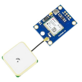
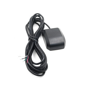
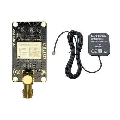
GNSS RTK module, dual band, Quectel LC29HDA, with YEGB000Q1A antenna
Professional GNSS RTK solution for stable centimeter-level positioning, ideal for automation, drones, measurements and monitoring in urban environments. Dual band L1 L5 reception with multi-constellation tracking GPS GLONASS Galileo BDS QZSS, high sensitivity with integrated SAW and LNA for interference resistance, UART I2C SPI interfaces and NMEA RTCM support. Includes YEGB000Q1A antenna.
Buying this product earns you Ft1,650.76 in loyalty points.

International fast shipping within EU. Free Shipping for orders above 100 EUR in most EU countries.

We ship from our stock within 24H

You earn points with every order, worth 5%.
The GNSS module with Quectel LC29HDA represents a professional high-precision positioning solution, designed for applications where accuracy and location stability are essential. Based on RTK (Real-Time Kinematic) technology, the module achieves a positioning accuracy of 1 cm + 1 ppm CEP 50%, with an RTK convergence time under 10 seconds, making it suitable for field robotics, precision agriculture, UAV systems, surveying, or any industrial application where standard GPS is not sufficient.
Dual-band reception L1 and L5 allows tracking a larger number of satellites simultaneously and provides significantly better resistance to multipath errors, frequently encountered in dense urban environments or near metal structures. The module supports GPS, GLONASS, Galileo, BDS, and QZSS constellations, ensuring global coverage and high signal redundancy. Autonomous accuracy (without RTK) is 1 m CEP 50%, and speed accuracy is 0.03 m/s, with a precise 1PPS signal at 20 ns.
Integrated SAW filters and LNA amplifier contribute to superior sensitivity during acquisition (-145 dBm) and tracking (-165 dBm), as well as good RF interference rejection, useful in industrial or crowded urban areas. The 12 nm process architecture ensures low power consumption: 25 mA in active mode and only 25 µA in backup mode, significantly extending the autonomy of battery-powered devices.Communication is done via UART (default 115200 bps, adjustable up to 3 Mbps), with additional support for I2C and SPI.
The protocol used is NMEA 0183 for navigation data and RTCM 3.x for RTK corrections.
The module is compatible with ESP32, STM32, Raspberry Pi platforms, and any microcontroller or single-board computer with hardware UART interface and logic level of 2.8-3.3V, or with an appropriate level converter for boards with higher logic voltages.
Attention regarding compatibility with Arduino Uno R3: The module is not functionally compatible with Arduino Uno R3 or other boards based on ATmega328P. The default communication speed of 115200 bps exceeds the practical limit of SoftwareSerial on this platform, resulting in corrupted unusable NMEA data regardless of the applied software configuration. The Uno's 3.3V pin is limited to 50 mA and may be insufficient for stable module power during active acquisition. It is recommended to use an ESP32, Arduino Mega (with dedicated hardware Serial), or any platform with native hardware UART at 3.3V.
Real test results: Tested with YEGB000Q1A antenna positioned at a window in an urban environment, the module obtained an autonomous GPS fix in less than 60 seconds from cold start, receiving 32 satellites with HDOP 0.47 and an estimated accuracy of approximately 1.2 m under partial sky visibility conditions. Outdoors with full visibility, the number of satellites and precision are significantly better, approaching the theoretical specification of 1 m CEP.
Specifications:
Power supply voltage: 3.1 - 3.6 VDC
I/O voltage: 2.8 - 3.3 VDC
Acquisition current consumption: 25 mA
Tracking current consumption: 25 mA
Backup mode current consumption: 25 µA
Supported bands: GPS/QZSS L1 C/A, L5; GLONASS L1; Galileo E1, E5a; BDS B1I, B2a
Default constellations: GPS + GLONASS + Galileo + BDS + QZSS (4+ QZSS)
Autonomous position accuracy: 1 m CEP 50%
RTK position accuracy: 1 cm + 1 ppm CEP 50%
Speed accuracy: 0.03 m/s
1PPS signal accuracy: 20 ns
RTK convergence time: < 10 s
TTFF with AGNSS: 5 seconds (full cold start)
TTFF without AGNSS: 26 seconds (cold), 16 seconds (warm), 1 second (hot)
Acquisition sensitivity: -145 dBm
Tracking sensitivity: -165 dBm
Re-acquisition sensitivity: -157 dBm
UART interface: up to 400 kbps, adjustable up to 3 Mbps (default 115200 bps)
Additional interfaces: I2C, SPI
Protocol: NMEA 0183 / RTCM 3.x
Maximum altitude: 10000 m
Maximum speed: 500 m/s
Maximum acceleration: 4 g
RTK navigation update rate: 1 Hz
GNSS raw data update rate: 1 Hz
Antenna model: YEGB000Q1A
Operating temperature: -40 ~ 85°C
Module dimensions: 21 x 39.6 mm
Antenna dimensions: 62 x 56 x 23 mm
Module weight: 5 g
Antenna weight: 105 g
Usage:
Connect the module to a stable 3.3 VDC power supply capable of delivering at least 100 mA to cover acquisition peak consumption. Do not use the Arduino Uno R3 3.3V pin as it is limited to 50 mA.
Connect the module's TX pin to the development board's hardware RX pin and the module's RX pin to the board's hardware TX pin. Use only hardware UART ports — SoftwareSerial is not compatible at the default speed of 115200 bps.
For reading, without sending commands to the GPS, only connect the GPS TX pin to the Microcontroller RX; no logic level converters are needed.
If the development board uses 3.3V logic (ESP32, STM32, etc.), the connection is direct. For 5V logic boards, use a bidirectional level converter on TX and RX lines.
Place the YEGB000Q1A antenna with direct and unobstructed sky visibility.
At startup, the module automatically begins satellite acquisition and transmits NMEA 0183 data on UART at 115200 bps. Check for the GNGGA sentence with a fix field different from 0 to confirm active positioning.
Cold fix time without AGNSS is approximately 26 seconds under ideal signal conditions. In urban or window environments, wait up to 60 seconds.
To activate RTK mode, connect an RTCM 3.x correction source (local RTK base or NTRIP service via WiFi) to the module's RX pin and wait for convergence under 10 seconds.
To reduce consumption in battery-powered applications, send the command to enter backup mode via UART. Consumption will drop to 25 µA until the next activation.
If using I2C or SPI instead of UART, reconfigure the active interface via the module's proprietary commands before switching physical connections.
Ensure that motion parameters do not exceed specified limits (500 m/s, 10000 m, 4 g) to avoid losing fix in mobile or aerial applications.
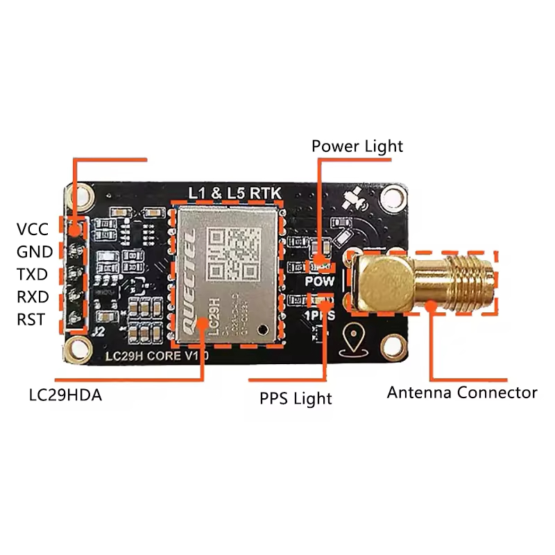
Module layout:
| Pin Number | Pin Name | Pin Description |
|---|---|---|
| 1 (V) | VCC | Power supply 3.1–3.6 VDC (Standard 3.3 VDC) |
| 2 (G) | GND | Ground |
| 3 (T) | TX | Data transmission (2.8-3.3V) |
| 4 (R) | RX | Data reception (2.8-3.3V) |
| 5 (RST) | Reset | Reset |
Antenna dimensions:
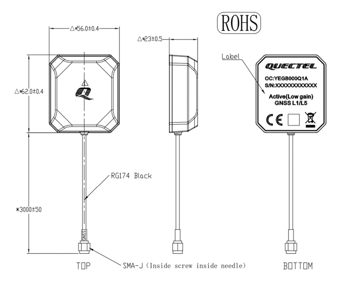
PQTM Commands:
General for LC29HDA NR11A03S_RSA firmware (March 19, 2024). Commands depend on the firmware, and below are the manufacturer's commands (https://www.quectel.com/content/uploads/2022/02/Quectel_LC29H_SeriesLC79HAL_GNSS_Protocol_Specification_V1.4.pdf). These have been partially tested.
PQTM:
| Command | Function |
|---|---|
$PQTMVERNO |
Query firmware version |
$PQTMSAVEPAR |
Saves configuration to flash (NVM) |
$PQTMRESTOREPAR |
Reset all PQTM settings to default values |
$PQTMEPE |
Output estimated position error N/E/D/2D/3D |
$PQTMCFGMSGRATE,W,, |
Set output rate for any message |
$PQTMCFGGEOFENCE |
Configure geofencing zone |
$PQTMGEOFENCESTATUS |
Query geofencing status |
$PQTMCFGSVIN |
Configure RTK base position in XYZ coordinates |
$PQTMSVINSTATUS |
Query RTK base survey-in status |
$PQTMGNSSSTART |
Start GNSS engine |
$PQTMGNSSSTOP |
Stop GNSS engine |
$PQTMPVT |
Output position/velocity/time in a single message |
$PQTMCFGNMEADP |
Set decimal precision of NMEA fields |
$PQTMCFGRCVRMODE,W,1 |
Set receiver mode to Rover RTK |
$PQTMCFGRCVRMODE,W,2 |
Set receiver mode to RTK Base |
$PQTMCFGRCVRMODE,R |
Query current receiver mode |
$PQTMPL |
Query position protection level |
$PQTMCOLD |
Cold restart (erase all NVRAM data) |
$PQTMHOT |
Hot restart (keep NVRAM data) |
$PQTMWARM |
Warm restart |
$PQTMSRR |
Complete software reset of the module |
$PQTMCFGSBAS |
Configure SBAS (WAAS/EGNOS) |
$PQTMCFGCNST |
Select/query active constellations |
$PQTMDOP |
Query current DOP values |
$PQTMCFGFIXRATE |
Set/query position update rate |
$PQTMCFGPPS |
Configure 1PPS signal (polarity, latency) |
$PQTMDEBUGON |
Enable debug messages |
$PQTMDEBUGOFF |
Disable debug messages |
$PQTMVEL |
Output detailed velocity on N/E/D axes |
$PQTMCFGODO |
Configure internal odometer |
$PQTMRESETODO |
Reset internal odometer |
$PQTMODO |
Query odometer data |
$PQTMANTENNASTATUS |
Query antenna status |
$PQTMCFGANTENNA |
Configure antenna behavior |
$PQTMCFGUART |
Configure UART speed |
PAIR:
| Command | Function |
|---|---|
$PAIR001 |
Generic ACK for PAIR commands |
$PAIR010 |
Start GNSS system (DSP, RF, PE, clock) |
$PAIR020 |
Stop GNSS system |
$PAIR030 |
Hot restart (uses all data from NVRAM) |
$PAIR040 |
Warm restart (erases ephemeris data) |
$PAIR050, |
Set position output interval in milliseconds |
$PAIR062,,<0/1> |
Enable/disable individual NMEA messages |
$PAIR066 |
Query/configure fix rate |
$PAIR080 |
Set navigation mode |
$PAIR081 |
Query navigation mode |
$PAIR432,<0/1> |
Enable/disable RTCM3 MSM7 output (base mode) |
$PAIR434,<0/1> |
Enable/disable RTCM3 antenna position output 1005 |
PAIR062 message index for enabling/disabling NMEA:
| Index | NMEA Message | Enable Example | Disable Example |
|---|---|---|---|
| 0 | GGA | $PAIR062,0,1*3F |
$PAIR062,0,0*3E |
| 1 | GLL | $PAIR062,1,1*3E |
$PAIR062,1,0*3F |
| 2 | GSA | $PAIR062,2,1*3D |
$PAIR062,2,0*3C |
| 3 | GSV | $PAIR062,3,1*3C |
$PAIR062,3,0*3D |
| 4 | RMC | $PAIR062,4,1*3B |
$PAIR062,4,0*3A |
| 5 | VTG | $PAIR062,5,1*3A |
$PAIR062,5,0*3B |
| 6 | ZDA | $PAIR062,6,1*39 |
$PAIR062,6,0*38 |
PAIR001 error codes:
| Code | Meaning |
|---|---|
| 0 | Success |
| 1 | Invalid parameters |
| 2 | Execution failed |
| 3 | Unsupported command |
Examples of commands to enable and disable NMEA sentences:
| Command | Function |
|---|---|
$PAIR062,0,0*3E |
Disable GGA |
$PAIR062,0,1*3F |
Enable GGA |
$PAIR062,1,0*3F |
Disable GLL |
$PAIR062,1,1*3E |
Enable GLL |
$PAIR062,2,0*3C |
Disable GSA |
$PAIR062,2,1*3D |
Enable GSA |
$PAIR062,3,0*3D |
Disable GSV |
$PAIR062,3,1*3C |
Enable GSV |
$PAIR062,4,0*3A |
Disable RMC |
$PAIR062,4,1*3B |
Enable RMC |
$PAIR062,5,0*3B |
Disable VTG |
$PAIR062,5,1*3A |
Enable VTG |
$PAIR062,6,0*38 |
Disable ZDA |
$PAIR062,6,1*39 |
Enable ZDA |
ESP32 Test:
| GPS Pin | GPS Name | ESP32 Pin | Notes |
|---|---|---|---|
| 1 (V) | VCC | 3.3V | Max 50mA - sufficient |
| 2 (G) | GND | GND | Common ground required |
| 3 (T) | TX | IO25 | GPS data to ESP32 |
| 4 (R) | RX | IO26 | ESP32 data to GPS |
| 5 (RST) | RESET | - | Not connected |
Package contents:
1 x LC29H DA Module
1 x YEGB000Q1A Antenna
Produs destinat utilizarii in proiecte electronice, automatizari, prototipare, educatie si cercetare.
Produsul trebuie utilizat numai conform specificatiilor tehnice mentionate in descriere si/sau in documentatia produsului.
Avertismente generale de siguranta:
Nu utilizati produsul la tensiuni, curenti sau temperaturi peste valorile specificate.
Montajul si conectarea trebuie realizate de persoane cu cunostinte tehnice minime in domeniul electric/electronic.
Evitati scurtcircuitele, inversarea polaritatii si conectarea gresita a alimentarii.
Nu lasati produsul alimentat nesupravegheat in timpul testelor.
Produsul nu este jucarie si nu este destinat copiilor.
Pentru modulele electronice, se recomanda utilizarea in carcase, panouri sau montaje protejate, dupa caz.
Identificare produs:
Denumirea produsului, codul/SKU-ul si caracteristicile tehnice sunt mentionate in pagina produsului si/sau pe eticheta ambalajului.
Producator / Importator / Distribuitor:
Sigmanortec S.R.L.
Calea Bucuresti nr. 9, Targu Jiu, Gorj, Romania
E-mail: [email protected]
Website: www.sigmanortec.ro
Persoana responsabila in UE:
Sigmanortec S.R.L.
Calea Bucuresti nr. 9, Targu Jiu, Gorj, Romania
E-mail: [email protected]
Documentatie si siguranta:
Pentru informatii suplimentare, fise tehnice, declaratii de conformitate sau instructiuni, ne puteti contacta la [email protected].
// LC29HDA - firmware version + NMEA monitor
// GPS TX -> IO25 | GPS RX -> IO26
#define GPS_BAUD 115200
String gpsBuffer = "";
void setup() {
Serial.begin(115200);
Serial2.begin(GPS_BAUD, SERIAL_8N1, 25, 26);
delay(500);
// Query firmware version
Serial2.print("$PQTMVERNO*58\r\n");
Serial.println("LC29HDA ready - waiting for data...");
}
void loop() {
while (Serial2.available()) {
char c = Serial2.read();
if (c == '\n') {
gpsBuffer.trim();
if (gpsBuffer.startsWith("$PQTMVERNO")) {
Serial.print("[FW] ");
}
if (gpsBuffer.length() > 0) {
Serial.println(gpsBuffer);
}
gpsBuffer = "";
} else if (c != '\r') {
gpsBuffer += c;
}
}
}